Maps and the Changing European View of the World: 1350-1700
(Most map images are courtesy of Henry Davis Consulting at Henry-Davis.com and the Cartographic Images site.)
Beginning even before Columbus' voyage in 1492, Europeans extended their view of the world, and relocated themselves in it to cope with a flood of new information brought back by merchants and military adventurers. Surviving maps and navigational charts are excellent sources of information about how they changed their view of themselves and their world. Orientation and shape are two crucial details of map-making which we often take for granted. Answer the question "which end is up?" in a map and you learn something crucial about the map's makers' sense of direction, and answer the question "what's at the center?" in a map and you learn something crucial about the map's makers' sense of values. Many medieval maps were oriented with East at the top, since that's the direction from which strange new things came (including silk, spices, and the plague). They also tended to situate the Mediterranean Sea at the center. The corollary question, "what's most prominently marked?" reveals that Jerusalem and Rome tended to be the most common prominent human-made features on these early maps. See, for example, the 1323 world map by Pietro Vesconte. (For most of these maps, a scholarly monograph describing them may be found on a hyperlink directly below the map, and for this one, an outline of the map oriented north-up is also provided so you can better identify the Iberian peninsula, the British isles, a reduced African continent separated by the Red Sea from a reduced Asia. The fact that north-up orientation makes this so much easier for us is a sign of our own normative construction of "the world.") This same east-up, Mediterranean-centered pattern can be found in the 1350 map which accompanied Ranulf Higden's Polychronicon, an extremely popular world history in manuscript editions and the first world history printed in English translation by William Caxton (1482).
Though many Anglo-European students are taught that exploration began with Columbus' voyage, navigators from Mediterranean and Scandinavian kingdoms had been making long speculative trading and settlement voyages for much of the fifteenth century. One of the Norsemen, perhaps as early as 1440, produced the famous "Vinland Map." This clearly delineates the Newfoundland coast, and roughly locates the St. Lawrence River estuary and Hudson's Bay, though the latter is reduced in scale. The land mass is more or less correctly situated with respect to Iceland and Greenland. The British Isles are somewhat reduced in size, and the Azores are expanded in their location off the coast of Saharan Africa. This unique document's information about the American continent is not found in any other contemporary map or chart for nearly sixty years. For instance, the navigational chart identified in 1924 by Charles de La Roncier as one produced for or used by Columbus (c. 1492?, still debated) shows nothing west of the Azores. Consult the monograph for a black-and-white outline of the chart, but also note that it did not need to be re-oriented to a north-up position. Columbus already was thinking about navigation in the open sea, with a north-pointing magnetic compass and star chart organized around Polaris, the northern hemisphere's "pole star," as his only means of converting real-world observations into points on the map. Columbus also was well aware of how the new technology of printing could improve public awareness of the importance of his voyage, as he proved with the 1494 publication of the "Columbus Letter," which you can see at the University of Southern Maine's site dedicated to it.
The sixteenth century marks the greatest increase in Anglo-European geographic knowledge for thousands of years, and it very quickly established the East Coast of the Americas as a navigable region at the periphery of a Eurocentric world-view. As early as 1507, Martin Waldseem�ller first used the term "America" to identify, as a single entity, the bulk of the continent in the vicinity of (perhaps) northern Argentina. Click here for the magnified view of that portion of the map, but note it represents as a narrow island the mere western coast of the entire continents of North and South America. Magellan's 1520-1 circumnavigation provided significant new details of the world's shape. The 1526 map by Juan Vespucci, nephew and heir of Amerigo, represents a vast increase in cartographic detail for the East and West coasts of the Americas in only twenty years of exploration. Diego Ribero's 1529 map corrects the curved distortion of the Vespucci map and further increases the level of detail, producing perhaps the best map of the era. Sebastian Cabot's 1540 world map depicts the Eastern and Western hemispheres in something approaching the same degree of proportionate detail. Gerard Mercator's "Nova Et Aucta Orbis Terrae Descriptio Ad Usum Navigantium emendate . . ." (1569) produces the first world-projection of Mercator's system of correction for the curvature of the Earth.
John Speed's 1627 world map gives us a combination of Mercator's more accurate rendering of the globe on a two-dimensional plane with high degree of detail for both hemispheres. The map illustrates European understandings of the shape of the world, following Mercator's north-up, Atlantic-ocean-centered projection, at the close of the most rapid growth in their geographic knowledge. Note that California's Sea of Cortez has not yet been fully explored, but its great extent has convinced the cartographer California is an island. Remaining to be discovered are Australia, New Zealand, and the full extent of the Arctic and Antarctic ice sheets, as well as many of the smaller Pacific island chains. The Pacific Ocean, the planet's single largest topographical feature, remains marginalized in Speed's vision, as it is for most 20th-century inhabitants of England and America. Our Atlantic-centered world remained a constant in history and in politics until (for some Americans, at least), the bombing of Pearl Harbor by a Japanese fleet under the command of Admiral Yamamoto and Admiral Nagumo, on December 7, 1941. Residents of Australia and New Zeeland have promoted "south-up" maps to challenge the Northern-Hemisphere-oriented view of the globe. They're good for rethinking your planetary identity, because when one approaches a spinning planet from outer space, there's no necessary "up," but either of the poles can argue equally for authority.
From the mid-seventeenth century, "discovery" took place within a more nearly closed geographic system, filling in the "terra incognito" spaces on pre-existing continents. However, at nearly the same time, the size of the known universe had been expanding due to the researches of Kepler, Gallileo, and Newton, who helped us understand . The combination of the two shifts in universal orientation produced something like the one held by thinkers until the early part of the 20th century when radio-astronomy and particle physics once again destabilized our sense of place in the universe.
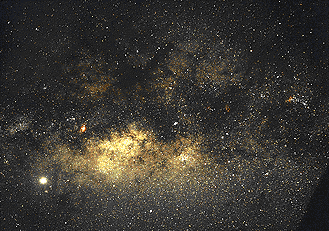
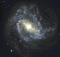
The Milky Way Galaxy from the Southern Hemisphere Galaxy M81, a spiral arm galaxy similar to our own. We see galactic center (left image) from 2/3 of the way out on a spiral arm. Click here for your location.
Click here for "Powers of Ten" (Florida State University), a "vertical" orientation to your place in the universe as a consciousness that is aware of itself as a being operating only within a few orders of magnitude when compared to the orders of magnitude known to modern physics. Before you start, imagine what it would be like to see all of those orders of being simultaneously instead of in "slices."